


Feature
By Bryan Simpkins, 7-16-25
Still another chapter of Bryan’s self-assigned goal to paddle the entire 130+ mile St Marys River, which starts in the Okenfenoke Swamp in Georgia.
I do not know if it is the distance I have to travel to get to the next section, the unknowns of this section, the distance I am planning on going or, the time frame I need to do it in but, I am nervous for the first time since the fog bank on my solo circumnavigation of St Simon’s Island. Just a moment of transparency before I totally commit mentally, physically and spiritually to the black water.
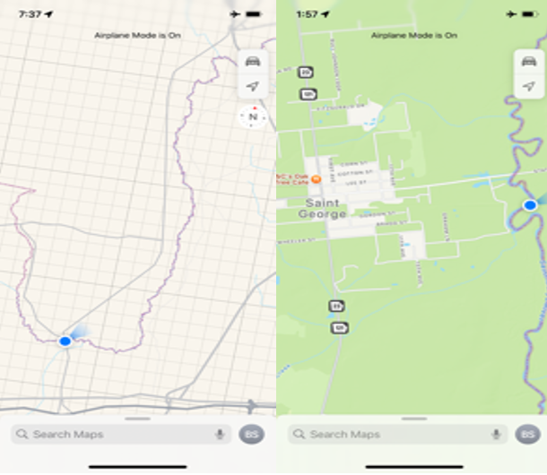
Between Google Earth and maps, I found that State road 121 North crosses the St Marys River just north of Maccleny Florida. After checking the river with waypoints from Google Earth I guesstimate that it is 25 miles to my pick up point in St George, Georgia.
Through the St Marys River-keeper site (which my friends Paul Lore and George Miller have helped me gather info from) I have learned that indeed, the tides do not affect the river this far back. So with only the afternoon rains and the unknowns of this new stretch, I have made the commitment, arranged the rides, secured the supplies and filled out my float plan.
This section will be the 4th in my attempt to complete the whole 130 miles of this amazing river. So far I have paddled from Boulogne Florida to Amelia island, where the black water river dumps into the Atlantic Ocean. Approximately 60 miles. Once I complete this section I guesstimate I will have 85 of the 130 miles completed.
I lightened the load of the kayak in hopes of making better than 4 mph. I removed the sea anchor and some of my open water supplies. It weighs 96 pounds without my food & beverage… and myself: 165 lbs. total weight.. somewhere around 265?
So quickly, my kayak is a 13’ 6” plastic sit-on Ocean Kayak Prowler. With a 240cm fiberglass paddle, leashes, life-vest, rope, 1st aid kit, knife, gel seat, dry bag w/change of clothes, VHF radio, 9mm, raincoat (this time), hat, sunglasses, headlamp, spare paddle, and food: Gatorade, water, V8 energy, fruit, granola bars, protein shakes and my dependable “UnCrustables” and I am set for an early start.
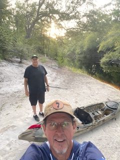
My first ride, to the drop off point: from Kent Fidler. He has been encouraging me since I started these “adventures” and has helped pick up, drop off, pray for and, track me. He’s good company.
Later, another friend who has been with me for many of these journeys, John Fournier, will pick me up. I sure hope to arrive at our planned destination on time…or earlier.
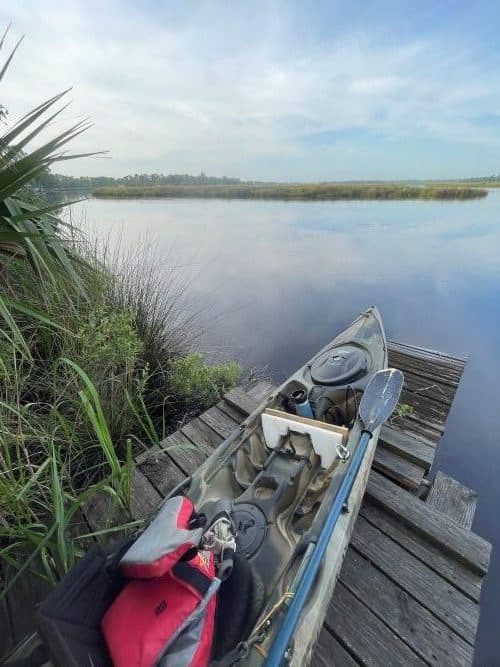
We loaded, in Yulee, before the sun was awake and drove an hour to Maccleny Florida and then jumped on SR 121 N. The bridge came upon us after a short distance and we had to drive past the river, past the guard rails and down a private driveway. We unloaded and carried the kayak almost a hundred yards, down a service road, over the rocks and down the embankment. Briars wrapped around my bare feet and left the marks that they were there.
IT IS BEAUTIFUL! Oh my! The white sand and the black water. Bonus, the flow of the river is to my advantage. So we took some pics, said a prayer for safety and I dug in. So much anxiety about what’s ahead and so much excitement as well. I had to yell a big Woooo as i took off, just to release the nerves.
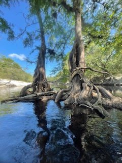
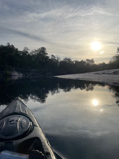
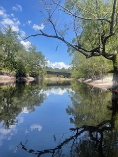
I never got bored. It is so quiet. The river winds and every turn reveals something more amazing than the area I just came from. Cypress and Oaks battling for the same piece of turf in the middle of the river. Root systems holding the bank back from the water.
I feel like I am making great time. The river isn’t wide back here and the water color goes from black to brown to orange and red as the varying levels of sandbars rise and fall. I passed over at least 3 sunken boats and there is a lot of debris in the water, mostly fallen trees. You need to be prepared to make quick adjustments so the current doesn’t pull you into the tangles.
Someone had been through before and used a chainsaw, in the tougher areas, to clear a path but many times i bounced off a fast section. The rain the night before helped raise the water level….and that increased the flow of the river.
I passed South prong Creek at 8:08 am. The sound of the waves breaking on the sandbar behind my kayak is awesome. I’m making amazing time. At 8:38 am the river widened and the current was noticeably slower. I felt the full weight of the kayak then. But, at 9:11 am it narrowed again. This was my normal for the rest of the way… but it was mostly narrower.
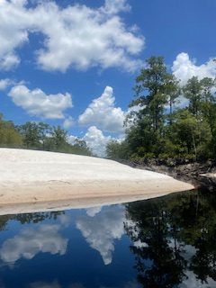
Occasionally I would stop on a sandbar and get out. Whether to stretch or snack… I just had to take in all this scenery. High banks, debris 20 feet up in the trees from previous floods, your imagination runs wild. You have to pay attention to enjoy all this scenery when you are on a timed paddle.
So eventually the shade of the forest faded further back off the shore and the sun hovered over me. The temperature quickly rose and the sunscreen wasn’t enough. I had to put the long sleeve shirt back on. 96 degrees was the high and I have no clue what the heat index was, but it was hot! Drink fluids. Eat the fruit. When i stopped to take a video I could hear my deep breathing… the pace was quick.
Mile after mile the blade slid through the glassy water, this time I only captured my location on maps by taking a screen shot. Usually I use Map-My-Walk to track my trip. The problem is, my phone battery usually dies when I do this so I tried something new this trip. (The good news is that at the end of my trip I still had 75% of my battery left). But Map-My-Walk tracks my speed, strokes, distance and many other things. Now I won’t have that.
I passed a bridge (unknown what road it was at the time but I later found out it was CR 3 / Stokes Road) and worked the twisting and winding creek to a section I dubbed the 360. I planned to stay to the right, the shorter section, but followed the heavier current to the left and went through a real tight, fast section. Back on the main channel, this means County Road 2 was next and I was approximately half way.
A couple more hours of paddling and I heard music. As I rounded another amazing sandbar I saw only the third person I have encountered on the whole 25 mile trip (previously only 2 boats with some older gentleman fishing).
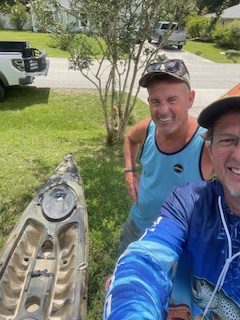
I saw the bridge at CR 2 and spotted my ride. John had just pulled up to the boat ramp and captured me rounding the bend and beaching on the ramp! Heck yeah. How’s that for timing? 25 miles in 6.5 hours.
I feel like I need to work on my diet for these longer trips. Maybe a little nutritional education would benefit me? I am light headed and exhausted.
Well…. This was by far my favorite section of the whole river. Having already done Boulogne to Kings Ferry, Kings Ferry to I-95 and, I-95 to the Atlantic Ocean (Amelia Island) this section blew the others away. So that means 85 miles of the 130 are complete. This also has me inspired me to do the Moniac to Maccleny leg next. Then that will leave the St. George to Boulogne leg as the last one….maybe 2?
Memories of whirlpools and boiling water, turtles, gators and turkeys are vivid still. Spanish moss and the silence of nature. That beautiful winding black water is calling and I daydream, while I am at work, of the next opportunity to explore God’s amazing creation by kayak as I set out to complete the whole 130 miles of St. Marys River. From the Okefenokee Swamp to the Atlantic Ocean.
I hope this inspires you to try. See you on the water
Bryan Simpkins
all photos were taken by the author.
Editor’s notes: Mr. Simpkins is much too modest. Being a 30+ year paddler myself with quite a few trips under my belt as well, I could readily see that he is a very strong, thinking paddler. To complete such a trip all with a short, slow plastic kayak is quite an accomplishment in itself. To do it alone, without co-paddlers is even more difficult, although he had transportation to and from his route. He carefully planned and executed this trip to arrive at all the right points at the right time, tide and currents for maximum performance and safety. It’s really hard to see ahead to know where to turn,, not that there are even accurate charts of the marshes, shoals and sandbars.


