


Feature
By Bryan Simpkins, 12-3-24
Fog! I didn’t plan for the FOG!
I Preloaded everything Tuesday night and made copies of my float plan. I gave one to my wife and put one in the Jeep. The last time I tried to circumnavigate St Simons and Little St Simons it didn’t go well. But that was 3 months ago.
Checking the weather & wind for the hundredth time, these were my thoughts, “If I leave Amelia island at 4am I can be the boat ramp on Lanier island at 5am. Launch in the dark, cross over to St. Simons and ride the tide for 52 minutes up Frederica River. Slack tide will happen and if I dig I can make the break and catch the outgoing to the ocean.” That’s the plan right now, Tuesday evening. The wind is WSW 5mph, and expected to drop, but that should reduce the waves on the ocean side. There is a ESE swell and rain chance is 0%.
After the Cumberland fiasco I’ve added the moon to things I look for. This one will be a crescent with 36% visibility. I also know the sunrise and sunset so I’m good.
I backed down the ramp on Lanier island and it was very dark. Unloaded my 13’ ocean kayak, turned on the LED’s and lantern and that’s when I realized the fog. This is a game changer. I hadn’t planned for Fog. I almost bailed on the trip, that’s how bad it was. I wasn’t prepared for this but I’ve waited too long and the island has already beat me once. I imagined this is what climbers on Everest say before they push past common sense and freeze to death.
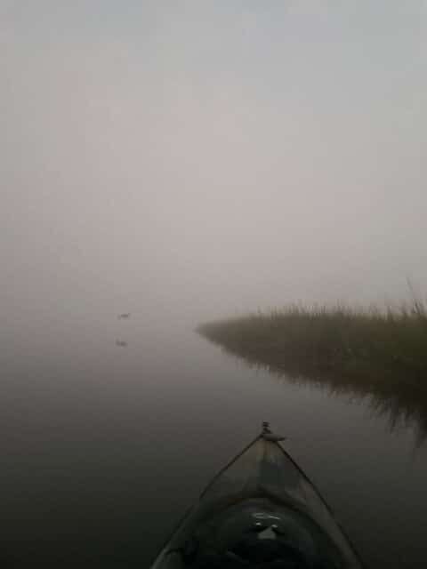
Imagine sitting in front of a giant white sheet. That’s what it was like paddling. I thought to myself often, “Am I going anywhere?” After paddling for about 20 minutes I see some red lights glowing through the wet mist. It’s a bridge! it’s the bridge…with the boat ramp just like the one I just launched from! I’ve now made a complete circle! More importantly I’ve lost a precious half hour. So I pulled out my navigational system on my phone (I should’ve done that to begin with. Lessons learned!)
I really didn’t want to use it this early. I know the north end has no cell service and it will be crucial to have as I work through the various creeks and inlets that lead to nowhere. What a relief to be able to track my path! I crossed the Mackey river, found the marsh grass on St Simons and kept it 2 feet away from my starboard side. It’s was my safety net for the next couple of hours, until the sun attempted to break through.
For hours it was all I had to look at. Marsh grass and mud banks. Occasionally I’d peek at the navigational map but the Frederica river is pretty much a straight shot up. No side creeks to worry about turning the wrong way into.
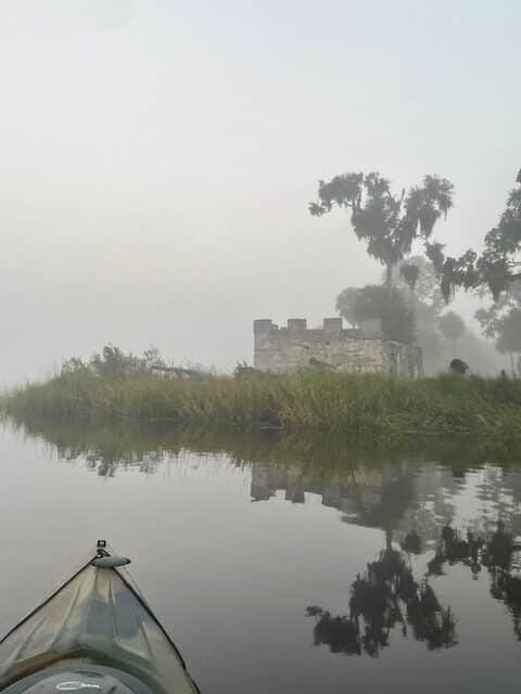
Around 8am a sailboat moored just 50 feet from the fort gave an eerie glow and helped me get a really cool photo of the brick and cannons. I want to come back and drive to this place. It seems like it would be fun to investigate. But a few strokes on the paddle and it faded into the white soup as quickly as it appeared.
By the way, the fog will play with your mind. I saw structures that weren’t there and the layers boiled like a witch’s brew in a cauldron. I would strain to focus and second guess paddling towards whatever my mind thought was there.
Eventually the fog started breaking and I could see across the river, just in time. It was around 9am that I reached the area that defeated me on my last attempt. The lifting fog gave me a moment of relief and I’m grateful to have plenty of battery power “Wait! What!!” How did it drop to 10% so fast? Paddle harder! Paddle faster!
I found the Hampton River entrance and the outgoing tide. I’m happy to be in familiar territory. On my failed attempt 3 months ago I found Greer & Michelle at the Hampton River Marina. They rescued me. They allowed me to tie up to the dock and gave me a ride back to the boat ramp at Lanier. So I decided to stop in and say hello.

The sun is more prevalent than the fog now. While Michelle is charging my phone for me we chitchat about family and future, about successful circumnavigations of Fanning, Fort George, the Talbots, Amelia, Cumberland and Jekyll. I’m blessed to have the passion and ability to do this. So, at 47% battery we parted ways and off towards the ocean I went…. Full of confidence.
A lot of boat traffic today. Everyone’s fishing the oyster beds along the river. They’ll hit one for about 15 minutes and then move to another. Along the way they start chatting with me. “Where are you going today?” they’d ask. You are everywhere! I tell them I’m 20 miles into a 30+ mile trip. They wave and off I’d go.
No sharks this trip. Only a couple of gators. The occasional shy turtle and the schools of mullet kept me entertained as the battle for the skies continued between the fog and the sun. It’s overcast and cool in November.
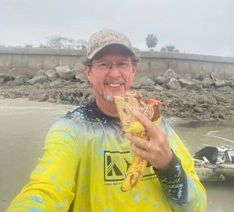
I reached the sea wall on the north end, between Sea Island and Little St. Simons then decided it’s time to eat. I beached the kayak and climbed up on the wall. PB & J, a banana and a Gatorade are my choice of nourishment. It feels good to stretch my back and walk around….but I’m behind schedule but a few minutes to limber up are appreciated by my lumbar and sciatic nerve, haha.
I am so glad there is no surf. Growing up surfing on Amelia I never dreamed I’d hear my self say that, but the west winds overnight leveled the ocean flat. A smooth transition from river to ocean. I haven’t always had that and it has been very rough on other trips, almost filling and swamping the kayak with waves. I say a prayer of gratitude and set my sights on the lower channel at Sea Island.
Now the mud, sawgrass and oysters have turned into white beaches and people. One guy, probably a tourist, had waded out chest deep and we have a nod of agreement as I paddled past him. No words are necessary. We both know.
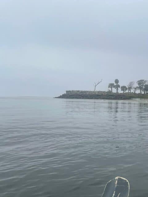
Around hour number 7, I passed the lower channel at Sea Island and was ready to round the southeast side of St Simons. I was looking for another place to stretch when I realized that there was a fishing pole every 15 to 20 feet. A massive ocean going cargo ship was heading out so I knew it would push a series of waves behind it and trying to navigate the fishing line, while getting swamped, didn’t sound exciting so I continued around the south end till I found a little bay and took a break. The lighthouse is always a welcoming sight.
The river was now muddy. The waves were foamy and was a lot of debris in the water. Nevertheless, I beached and just laid out prone on the hard sand, excited as I anticipated the finish line just around the corner. The tides worked out as planned but the time lost in the fog had me behind schedule about an hour and half… it was only 1pm and I’d hit the boat ramp around 3pm….so I just laid there, staring up into the sky, watching the gulls, the pelicans and the ospreys maneuver in the wind.
Okay, this was it. I pushed off, adjusted the silicon seat pad, rounded the rocks along the golf course and was met by an amazing schooner firing a cannon in the bay. Long white plumes of smoke rolled out across the water and the echo of the blast rolled through me like the Kick drum from a rock concert. It would’ve made a great photo but my 47% battery charge is long gone. Like so much of this trip, the pictures are in my mind, to be treasured, like Mary’s (hopefully you’ll get the reference) I just ponder them now.
First short term goal as I set out across the channel: the red channel marker. Next, the green. Find the creek entrance. Little goals like this kept me going when I was far enough off shore that I couldn’t measure my progress. I’d pick a house or a clump of trees and tell myself, “make it to there and then you can set another goal.”
That’s what these solo circumnavigations are really about. Time to reflect on the life that God has given me. Achieving personal victories so I feel alive. Leaving a “message in a bottle” for the next adventurer who is doing something new and encouraging others to keep seeking all that you were made to be.
Well, I made it. 34.74 miles in, let’s say, 10 hours. I drove 100 miles to paddle 35. I traded approximately 15 hours (including the packing, driving and kayaking time) of my life for this memory.
Here is a list of the supplies I took. I hope it helps you:
My kayak is an Ocean Kayak / 13’ Prowler. My paddle is my faithful 230cm fiberglass one piece. My gear includes an anchor, duct tape, 1st aid kit, dry bag with a towel, dry shirt & a hoodie, Wet wipes for my phone (so the salt mist won’t stop me from accessing it), gel seat, spare paddle, knife, floppy hat, gloves, socks (for my feet to protect from sunburn), bandana, LED lights (red &green), lantern, life jacket, pool noodle, surf leash, cordage, flashlight & head lamp, waterproof maps, and food: Uncrustables, trail mix, bananas, Gatorade, and a bunch of water.
Watch out for the FOG in November.
Bryan Simpkins
all photos were taken by the author.
Editor’s notes: Mr. Simpkins is much too modest. Being a 30+ year paddler myself with quite a few trips under my belt as well, I could readily see that he is a very strong, thinking paddler. To complete such a trip all with a short, slow plastic kayak is quite an accomplishment in itself. To do it utterly alone, without a support crew and co-paddlers is even more difficult. He carefully planned and executed this trip to arrive at all the right points at the right time, tide and currents for maximum performance and safety. There are some tricky waters, especially in the inlets and relentless tidal currents inshore. Time, darkness, wave, wind, currents, exhaustion, all weigh in. It’s really hard to see ahead to know where to turn at low tide, especially in the dark with your GPS out of battery power, not that there are even accurate charts of the marshes, shoals and sandbars.


