


Feature
By Bryan Simpkins, 5-27-24
Someone called it the trifecta, I don’t know about that? I like the Barrier Slam.
I am talking about solo circumnavigating Amelia, the Talbots and, Cumberland Island in a 13’ plastic kayak. 30 miles, 17 miles and 55 miles respectively.
I recently added Cumberland to my list of the barrier islands I’ve always wanted to paddle around. But unlike the Talbots’ northern sandbars & waves and, Amelia Islands opposing North Jetty, Cumberland had its secrets which you can only find out when you dare to accept the adventure. Most of the island makes up the Cumberland Island National Seashore.
As always it began with research. Part of that was trying to find anything about circumnavigating within 24 hours. Chirp chirp. Nothing. A lot of people have done it on multiple days by camping at various points around the island but, that’s not what I wanted to do.
Tides, swell direction, wind, sunset and sunrise are all part of any of my pre planning… but what was this “Pink Moon” thing? Keep reading to find out….
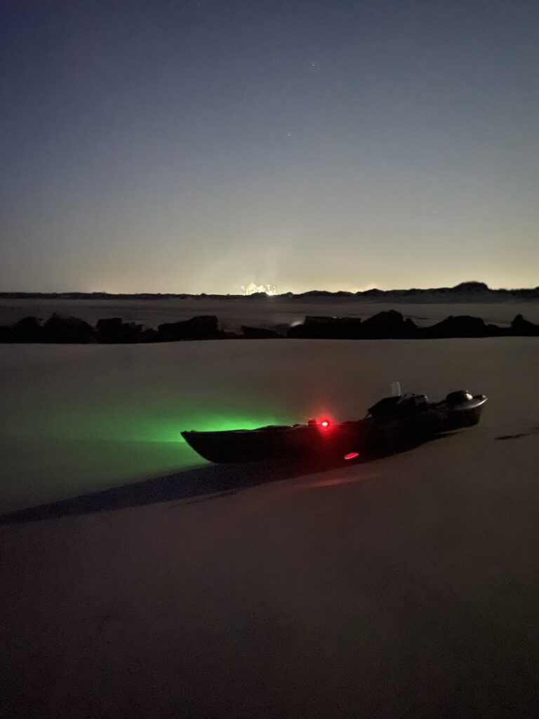
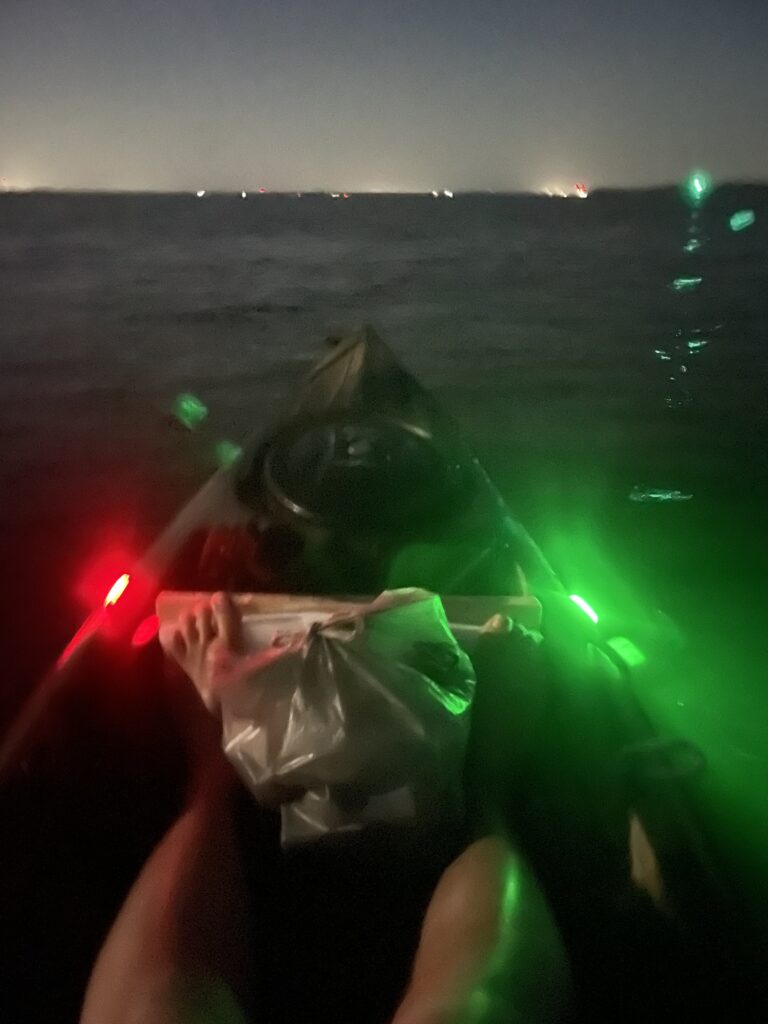
I left DD Bartyles boat ramp on Amelia island at 4:45am during the high tide and paddled across the channel in total darkness. Only shrimp boats and lights from somewhere up in Georgia on the horizon as markers. I had my green & red LED’s on the kayak and a lantern in the stern to let anyone who was out here know that I was crossing.
Seas were predicted to be 3’ and a last minute drive to the beach the previous evening verified that. Now I could hear the waves washing up the southern beach on Cumberland so I had to keep distance from the bank as I rode the outgoing tide around the corner so I wouldn’t get washed up the shore.
If you know Cumberland then you know the southern jetty has created a very large sand bar which the waves were now exploding on. I had to paddle further out in the channel than expected. But…. I avoided getting swamped and approached the Jetty cautiously.
In the faint moonlight it appeared as a giant wave. Intimidating. I hugged the edge to utilize the deeper pools to get as far up the beach, to where it began as possible. The glow of the LED’s made a beautiful and haunting image. I stepped into the water, drug the fully loaded kayak up and around the tip and back down onto the beach. It’s still very dark.
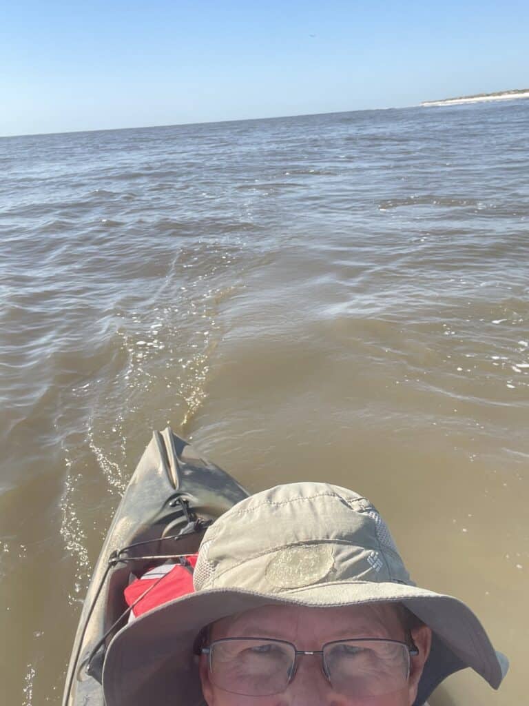
At 3 mph I can cover the 18 miles of the Atlantic Ocean side in 6 hours… but now I’m staring at the consistent (at least) 3 foot swell saying to myself, “There is no way I’ll get out past the break without soaking everything!” I looked for the edge of a sand bar, deeper water, but nothing. Plus… I know the fish with teeth prefer dusk and dawn as their time predate. I waded out to my chest, jumped in, ate a few waves but dug hard till I got to the outside.
My tracking map shows me getting pulled out to sea as I bailed water with my 16 ounce plastic cup. “8.8 pounds per gallon” kept running through my head. Take the extra time to get it all out!!
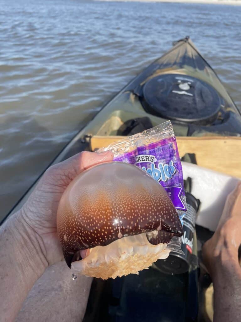
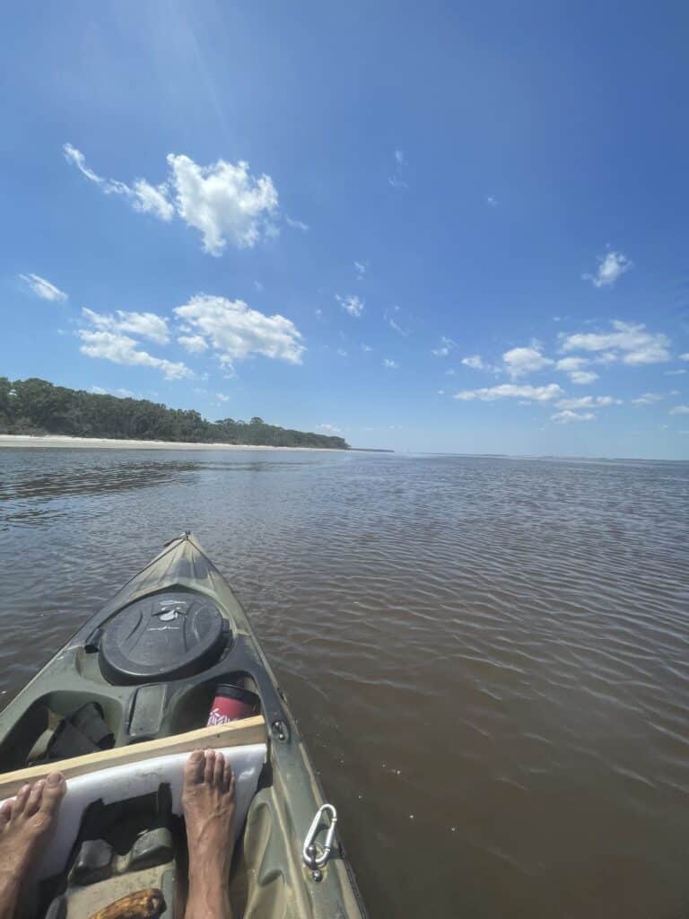
Once I hit that first stroke I was energized! The moon went down and the sun came up. Mile after mile. For humor I created landmarks to reach, calling them names I made up as I went. Soapbox, camel, the grove, all palm trees in different shapes. No people! Ever. Only the locals, which at this time had their young ponies, with them. Only horses to break up the monotony of pure wild Cumberland. The jelly ball invasion was on. The sun was also glaring.
Now I said at 3 mph I could do 18 miles in 6 hours, right. That was the plan because in 6 hours the tide will change and start to come in, propelling me behind the island. Well, I averaged 5.8 mph and after realizing I would never be able to paddle out far enough to avoid the millions of waves breaking on sandbars, I rode in to a slough of about 18” of water at Christmas Creek and paddled around the northern end of the island very close to the beach. It was at this point I met the still outgoing tide. I was on the wrong end of the rule of thirds.
I had planned to straight line from the inside of the creek to the other, avoiding the “S” pattern of following the inside bank of the creek BUT the now 15 mph South winds forced me to change my plan. It’s also important to note at this point that the plans I left for my wife did not include any “extra time” for breaks or delays. 3mph times 18 times 2 plus the width of the island and my “straight lining” equals 14 hours. Hahaha.
Everything on the marsh side of Cumberland is mud and oysters. No sand banks to stop and rest. Also, the low tide cut off my ability to see above the marsh grass so I’m forced to stay in wider creeks. Well, I knew sunset was at 8:22pm so I’m still good. It’s currently 1pm….but the tide is still going out.?!
I’ve never paddled so hard, so long and so fast in my career. The 1st African Baptist Church was somewhere inland behind me and Plum Orchard lay ahead. I’ve now spent as much time getting here, to this point, as I did on the ocean side the whole trip. Not good. Sun’s getting lower.
When I got to Plum Orchid a gator slid off the bank but I needed a break. I pulled the kayak up and laid down on the semi-sandy bank (by the boat dock). I watched the gator crawl back up into its spot on the bank, along side me, 15 feet away. Too tired to care.
The math isn’t adding up now. I have to do the math in my head because my phone has died and so did my backup battery. No photo evidence of the gator, you’ll just have to trust me. Side note: turn your phone on airplane mode if you try this AND have a wristwatch. Cumberland is the only barrier island I’ve kayaked around that does not have cell service.
I pushed off the bank after absorbing my protein shake and eating my Uncrustables, followed by a Red Bull. The gator nodded. I think it was impressed.
In the East river, north of the Greyfield Inn is a cozy little mud island with sea grass. It’s opposite of the Naval Base’s submarine hangars. That is where the sun set at promptly it’s predicted time. It is also the spot I said, “I can’t paddle another foot without some rest.”
I had made a last second decision at 4:45am that morning to leave my hoodie in the Jeep. So once I pulled the kayak up into the grass and took my towel out of my dry bag (which I placed my feet in) I wrapped the towel over my body and tried to fit into the molded plastic contours of the boat. With knife in hand and the tide still coming in (working against me) I fell asleep.
Lap, lap, lap…. The sound that woke me. What was that? I sat up and noticed the wind and (still rising tide) had pushed me deeper into the grass. “Well, as long as it doesn’t push me out of the grass…” and I dozed off again.
Apparently a Pink moon brings much higher tides than normal. Important to know.
Finally the tide has switched. I didn’t know what time it was, but I could see the lights from the bank at the Greyfield Inn. I turned on my headlamp (which wasn’t much help for distance) paddled hard to get under the protection of the giant oaks along Cumberland’s West Bank and was cruising at 5+mph as I passed some guys fishing. “Hello” I shouted. A few minutes later they pulled up along side me in their boat. “Are you Bryan,” They asked? That’s weird… yes, yes I’m Bryan. “You have a lot of people looking for you” they replied. “Do you want a lift back to the dock?” I replied “no, I’m almost home.” They said, “ We will let them know we found you and you’re continuing on.”
I passed Sea Camp and the Dungeoness dock. I’m cruising!! I passed where the St Mary’s river goes into Cumberland and then there she is, Amelia Island. The Port, West Rock…. And DD Bartyles. Now paddling hard against the ferocious south winds, along the southern end of Cumberland, another boat, with pretty blue and red lights pulled up next to me.
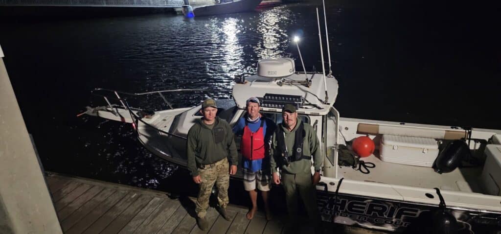
Before the short boat ride back to my starting point with the Camden Water unit I helped them push off the bank because the winds had driven their boat into the shallows while they helped me load my kayak on their boat. They informed me it was 1am and my family was at the docks with the NCSO who had also been looking for me. Apparently being 5 hours overdue is bad. Along with a watch and airplane mode I would recommend adding some fat to your guesstimate eta if you should ever try this.
Tired and relieved to be at the ramp I was extremely happy to have taken on the biggest of the barrier islands and completed it.
Inventory: 2 paddles (my main was a 230 cm fiberglass). Sunblock. Bug spray. Floppy hat. Gloves. Extra rope. First aid kit. Water, vitamin water, coke and sugar free Red Bull. Beef jerky. Trail mix. Uncrustables. Bananas and oranges. Dry bag with a towel. Red & green LED lights, a lantern. Headlamp and flashlight. Knife. Anchor.
I know more about myself now. I’ve pushed my ceiling and I’m super stoked. You’ve got to live the abundant life God wants for us. Outside is where it happens! Was it dangerous? Maybe. But I’m more alive now than before. I’ll definitely look for the “Pink Moon” info before the next trip (thank goodness it only happens once a year). But as I write this, I’d like you to know I’ve just circumnavigated Fort George and Fanning Islands. I won’t back down.
Walking in the light as He is in the light,
Bryan Simpkins
all photos were taken by the author.
Editor’s notes: Mr. Simpkins is much too modest. Being a 30+ year paddler myself with quite a few trips under my belt as well, I could readily see that he is a very strong, thinking paddler. To complete such a trip all with a short, slow plastic kayak is quite an accomplishment in itself. To do it utterly alone, without a support crew and co-paddlers is even more difficult. He carefully planned and executed this trip to arrive at all the right points at the right time, tide and currents for maximum performance and safety. But, nature intervened. There are some tricky waters, especially in the inlets and relentless tidal currents inshore. Time, darkness, wave, wind, currents, exhaustion, all weigh in. It’s really hard to see ahead to know where to turn at low tide, especially in the dark with your GPS out of battery power, not that there are even accurate charts of the marshes, shoals and sandbars.


